My husband, sister, nephew and I are going to climb Mt. Whitney sometime in August or September of 2011. My sister and nephew live near Placerville, Ca. and will be training in the Sierras. My husband and I live in La Jolla, Ca. and will be training in the Cuyamacas and San Jacinto Mountains. This blog will be a record of our training hikes and what we learn along the way.
The challenge: I just turned 60 this month! I have wanted to hike Mt. Whitney ever since my sister and I hiked half way up about 13 or 14 years ago. I don't know why I didn't just do it! I think it just seemed so overwhelming to me at the time. I guess at some point the desire had to overtake the procrastination. Now that I am 60, I realize that I'm not getting any younger and if I don't do it now, I may never do it! Over the years, I have talked to many people that have hiked Whitney and now I'm thinking what's the big deal? If one prepares properly, there is a better chance of succeeding and what the heck? If you don't try, you'll never do it! Also, if we try and don't make it to the top, at least we will have had the joy of training and trying!
So, today I'm filling out the 2011 Mt. Whitney Lottery Application. It has to be mailed between February 1st and March 15th. The Lottery will be held on Feb. 16th and the remaining empty spots will be filled after that. The application and information on how to apply can be found at: http://www.fs.usda.gov/Internet/FSE_DOCUMENTS/stelprdb5227396.pdf.
We're turning in 10 choices. I wonder if we should turn in more? This is the hard part, the part that has been keeping me from doing this all these years. So here goes!
Mt. Whitney Permit Lottery
I finished the application. I'll mail it tomorrow. There are a few things to note and a few things I was puzzled about.
Note: Permits are $15 per person, payable when you apply. I believe it is non-refundable, but could be wrong about that. There is a place to enter alternate group leaders, so list all of the the people in your party. That way if the original group leader drops out, one of the other people can still pick up the permits for the party.
The application asks for Entry Date, Exit Date, Entry Trail and Exit Trail and whether it is day use or overnight. I put the same date in each date field and the same trail for entry and exit. I hope that's correct. I know it was redundant, but I didn't want to leave anything blank and risk the application not being complete and getting rejected. There was space for 10 choices so I attached another sheet with 10 more choices. I added some Tuesdays and Thursdays just in case all of the weekend days are gone.
Backpacking vs Day Hiking
One of the reasons it has taken me so long to get around to hiking Mt. Whitney is that I believed that the only way to hike it was to do it in two or three days. Originally, I thought we would hike up to trail crest, spend the night, leave our overnight stuff there and hike to the top and back. Then either spend a second night, or continue to the bottom. This would have meant hiking about 6 miles the first day and about 16 the second day. It would have also meant sleeping at 12,000 feet.
The first time I went to Mt. Whitney, we camped at Whitney Portal, which is at about 8500 feet. I did not sleep the first night there. I could hear the blood pounding in my ears all night from the elevation. I realized that if I hiked to trail crest and tried to sleep there, I would not get much sleep. Not only would it be really cold and the air thin, but I would not have the benefit of the air mattress that I had when I camped at Whitney Portal.
OK. I have never been backpacking. The idea of it appeals to me, but the practicalities of it make me a little nervous.
So when an acquaintance told me he and his wife were hiking Whitney in one day, I immediately realized that that was the solution to my anxieties. I'd just do it in one day and then I wouldn't have to worry about sleeping at high elevation in the cold! (OK, I'm really a fair weather camper too!)
But Mt. Whitney is 22 miles round trip from Whitney Portal and I'm not as young as I used to be. I decided I would need to train a lot! So I talked my husband into training with me and now I think he will even hike to the top with me, even though it is my dream and not really his. What a guy!
The plan now is to drive up to Lone Pine, pick up our permits, check into our hotel, have a nice dinner, then go to bed. We'll get up around 2 am, get ready and drive up to Whitney Portal and set out around 4 am. We will set a time at which we will turn around whether we have reached the top or not, and we will also turn around if anyone gets serious altitude sickness. But hopefully we will all be in amazing shape by then and we will make it to the top. When we get back we will have the hotel waiting for us. We'll eat, jacuzzi and get a good night's sleep before we drive back home the following day. That is the plan and I think it's a good one! I can't wait!
Training Hike #1: Tahquitz Peak
I'm doing a bit of catch up here. When I started this blog we had already done 4 training hikes starting in October.
 Our first hike was Tahquitz Peak in the San Jacinto Mountains from the Devil's Slide parking lot. Round trip distance is 8 or 9 miles. The rangers said it was 8 but some other websites said it was 9. The elevation gain was 2500 feet so about 500 ft per mile. The top of the peak is at 8,828 ft. There were patches of snow the last few hundred feet before the top on the northern face of the peak. There is a lookout tower at the top. Amazing views and a great place to have lunch.
We were shooting for 2 miles an hour so it was a good workout for us. We made it up and back in 4.5 hours, so if it was indeed 9 miles, we made our goal. We did stay at the top for about half and hour for lunch.
We drove up to Idylwild on Friday evening, spent the night and hiked on Saturday. When we got back we were pretty sore, but the B and B we stayed at had a jacuzzi tub, so that was great! We drove back on Sunday morning. It was a great trip and a great first hike! I didn't get good pictures of the mountain though because my camera broke. All I got were pictures of my husband and I that I took on my cell phone. Actually, my current profile picture is from that hike. Hopefully I will have some pictures to post from our next hike.
I found a couple of good websites with information about this hike:
http://www.localhikes.com/Hikes/TahquitzDS_4472.asp
http://www.summitpost.org/tahquitz-peak/151446
Training Hike #2: Indian Canyons
Our second training hike was in November, the weekend before Thanksgiving. The plan was to have a little getaway in Palm Springs and take the Aerial Tram to Mountain Station at 8500 feet and hike to the top of Mt. San Jacinto at 10,834 feet (about 10 miles distance) for a little altitude training. Unfortunately it snowed the night before and we didn't really have snow clothes prepared, so we decided to check out the Indian Canyons instead.

 |
| One of many stone crossings on Murray Creek |
Saturday morning we set out to explore the Indian Canyons and hopefully get a 10 mile hike in. The Canyons were very close to where we were staying so it was very convenient. We paid a day use fee of $10 each at the tollgate and received a trail map. We wanted to hike near water, so Murray Canyon Trail and Palm Canyon Trail were recommended. We picked Murray Canyon trail, a 4 mile hike up and back that follows Murray Creek. The trail crossed back and forth across the creek on stepping stones and was shaded by beautiful palm trees. It was really lovely.
 |
| Three Sisters near end of Murray Canyon Trail |
 |
View of Murray Canyon from Coffman Trail
|
Another trail, West Fork North Trail joined Coffman trail about 1/4 mile out and continued up the ridge.
A sign said it was 3 3/4 miles (to where?). We decided to see how far we could get. This trail had a pretty steep incline and we made it about 3 miles up before we had to turn around due to the rain, the lateness of the day and the Canyon's closing time.
 |
| View of Rainbow from West Fork North Trail |
Speaking of the rain... it was raining in the mountains above us while we were hiking even though it was sunny in the valley. Occasionally we caught a little spray blown over by the wind. The effect of the weather was a huge rainbow that spanned the valley which we had a perfect veiw of for most of our hike! November is a great time of year to hike the Indian Canyons, as the weather is cool but not too cold.
I think if we had continued we would have reached the West Fork Trail and would have ended up eventually at Palm Canyon. We may try to do that hike at a later date. It was really good training for up and down hill, although I don't know what the elevation gain was.
By the time we got back to the parking lot, the park was about to close. We had walked continuousely for about 5 or 6 hours so we figured we got at least 10 miles in, if not more. We were pretty sore by then but had a great time.
For dinner that night we ate at Native Foods Cafe, which was also not far from our hotel (but not within walking distance). It's a really great vegan restaurant. What a find! It reminds be of Veggie Grill in Irvine which is also a favorite of mine. Why don't they have one in San Diego?
Training Hike #3: Cowles Mtn
The weather was turning bad, so we decided we needed to keep our hikes closer to home for a while. In San Diego, the weather is mild and you can hike all year round without having to deal with snow, rain, sub-zero temperatures, etc.
For our next hike we planned to check out Cowles Mtn. We had hiked it many times in the past, in fact I used to run it about once a week while my daughter was at dance classes nearby. I think that's how I wrecked my knees!
Our goal was to go out there and see how many times we could go up and down in a day. It's 3 miles round trip with an elevation gain of 950 in 1.5 miles so an average of 633 ft elevation gain per mile, vs Mt. Whitney with an average elevation gain of 545 ft per mile. The traffic on Cowles is crazy. It's gotten to be like a super highway. We must've passed at least a hundred people in 6 miles, so we decided to call it quits after two times. San Diegans are obsessed with working out in the out of doors and in the last few years Cowles Mtn has become the destination of choice for many people who like to do trail running. I remember climbing Cowles with our daughter when she was 6 or 7 (about 12 years ago) and there was hardly anyone else on the trail.
We decided to find another trail for our next hike.
Training Hike #4: Iron Mountain, Jan. 17, 2011
Yay! We found the best hiking spot!


Since this was our first time out on this trail we weren't sure how far we were from the junction to Iron Mountain so we decided to take the wide road back to Poway Rd.
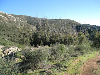
For our fourth training hike we decided to try Iron Mountain. I'd been there once before and it was pretty nice and not as crowded as Cowles Mtn.
It's 6.4 miles up and back with a nice side hike to Ellie Lane Staging Area (parking lot) that's 6.6 miles out and back from the junction about 1.75 miles from the start of the Iron Mountain trail at Poway Rd. So if you do both, you get 13 miles in. There are actually a few other side trails in addition to Ellie Lane. One is the Ramona Overlook trail which will add another 3 miles or so.
 |
| View from the top of Iron Mtn. |
For this first hike, we hiked to the top of Iron Mtn. and back to the parking lot (to fill up our water bottles and use the restroom). Then we started to hike up again but decided to take off toward the Ellie Lane Trail. There is a junction about .5 miles out that meets up with the Ellie Lane Trail.

It goes past two ponds and then hooks up with the trail.

The trail goes up and over one saddle. It's pretty steep and rugged, but really pretty. After the first saddle it goes down through a valley where there are actually three different routes you can take.

We took the western-most route which goes down to a nice creek and a grove of trees. From there you can either go left and continue up to another saddle and on to the junction and then up to the top of Iron Mountain or you can take the wide road to the right which continues around the first mountain and ends up back at the first pond and eventually back to the Poway Rd. Staging Area.
 |
| Beginning and end of Iron Mtn. Trail |
Since this was our first time out on this trail we weren't sure how far we were from the junction to Iron Mountain so we decided to take the wide road back to Poway Rd.
 |
| Wildflowers in January! |
We got back pretty early so we did another hike up the right hand trail (not the main trail) to Iron Mtn. About another 3 miles maybe. All in all we think we went about 11 miles in 5.5 hours.
Training Hike #5: Iron Mountain, Jan. 29, 2011
We were really curious about the Ellie Lane Trail so we went back to Iron Mtn. We didn't have a lot of time so we decided to try to do 10 miles in 5 hours.
We started up the Iron Mountain trail to the junction where if you go right it is 1.45 miles more to the top of Iron Mountain. If you go left it is 3.3 miles out to Ellie Lane Staging Area. We decided to go to Ellie Lane. This would give us 1.75 up to the junction, then 6.6 to Ellie Lane and back, then 1.75 miles back to Poway Rd. for a total 10.1 miles.
The Ellie Lane trail was fantastic. We had already been on part of it from the other direction, but it was really nice going north from the Iron Mtn. trail. We passed the Ramona Overlook trail about 3/4 of a mile out. About a mile out you get to the first saddle. The views all along this trail are spectacular. You can see down into parts of Ramona and east toward the Cuyamacas.
From the saddle you continue down and there are 3 routes you can take. The left trail goes farther west along the south side of the mountain to the grove of trees we had visited on our previous hike. The right trail crosses over to another mountain and stays to the east and travels high up on the side of that mountain. The third goes east along the side of the same mountain but a little lower down. We went to the right and took the high trail. This trail eventually ends up at table rock. There is a big tree to the west of table rock that has a picnic table where you can have a nice lunch in the shade. Table rock is at the saddle of the second hill. There are great views to the ocean from here. You continue over the saddle and down through a nice boulder area. Ellie Lane parking lot is about one mile from table rock.
We skipped the last few hundred yards to the parking lot and headed back up Ellie Lane Trail. On the way back we took the west road down to the grove of trees and then east back up to the last saddle. We got back to the Iron Mtn junction and took the southern trail (which is much smoother and more wooded than the northern and more traveled trail) back to the parking lot. 10 miles in 5 hours!
I have been experimenting with my shoes on these hikes. I have an old pair of hiking boots and a very worn pair of Merrel walking shoes. The shoes don't have much support and seem to be harder on my knees and the boots hurt my feet, but are better for my knees and back. I tend to alternate until I can afford to buy a new pair.
We started up the Iron Mountain trail to the junction where if you go right it is 1.45 miles more to the top of Iron Mountain. If you go left it is 3.3 miles out to Ellie Lane Staging Area. We decided to go to Ellie Lane. This would give us 1.75 up to the junction, then 6.6 to Ellie Lane and back, then 1.75 miles back to Poway Rd. for a total 10.1 miles.
 |
| View of Laguna Mtns from near Ramona Overlook Trail |
 |
| View toward Ramona from near the first saddle on the Ellie Lane trail heading north from Iron Mtn trail. |
We skipped the last few hundred yards to the parking lot and headed back up Ellie Lane Trail. On the way back we took the west road down to the grove of trees and then east back up to the last saddle. We got back to the Iron Mtn junction and took the southern trail (which is much smoother and more wooded than the northern and more traveled trail) back to the parking lot. 10 miles in 5 hours!
 |
| Just one of many wildflower shots that we took. Early rains in San Diego produced an abundance of wildflowers in January! |
Training Hike #6: Iron Mountain, Feb. 12, 2011
For this hike we got a late start, but we were determined to do the whole 13 miles. I wore the Merrell walking shoes thinking they would be easier on my feet. As it turned out, they were, but not so good for my knees. I really need to get some good hiking shoes!
We started at the Iron Mountain Parking lot at the intersection of Poway Rd. and Hwy. 67. We hiked to the junction with the Ellie Lane Trail 1.75 miles up, then we headed north on the Ellie Lane Trail.
The trail passes a turn off to the right for the Ramoma Overlook trail. This will be a possible extension to our next hike.
We continued up to the first saddle. From here there are beautiful views to the east and west. Then the trail starts down. There are three routes to take from here. There is a fork a short ways down where you can go right and cross over to the next small mountain and traverse around the west side, or you can take the fork to the left and continue down the north side of the hill and end up in the bottom of the canyon where the small grove of trees is. We had cut across and taken the highest route along the mountain side the last time and had come up through the grove of trees on the way back so we decided to take the right trail but stay on the lower path this time.
It was a great trail. Not too rocky and very pretty. It is my favorite route now. It ends up in the same place as the higher trail. Where the two trails meet you can either go up to table rock from there, or take a lower route that passes below Table Rock. We decided to take the lower route. This too was a really interesting trail. We eventually ended up at the next saddle by Table Rock.
 We then headed down to Ellie Lane which is about a mile from Table Rock. We went all the way down to the parking lot this time. The trail passes some homes and a really pretty field with cows, horses, sheep, squirrels, rabbits, etc.
Then we retraced our steps back up to Table Rock where we ate lunch at the picnic table that is hidden under the one big tree up there.
We continued back on the same trail we came on. The middle trail is really nice coming back too.
When we got back to the Iron Mountain trail we continued up to the top of Iron Mountain where we took a short break, then back down and making it back to our car just as the sun set.
My knee had started hurting about halfway through this hike. I eventually wrapped an ace bandage around it which helped a lot. It feels better now (10 days later).
We did the entire 13 mile hike in 6 hours and 15 minutes, so are keeping with our goal of 2 miles an hour.
The Iron Mountain/Ellie Lane trails are pretty rocky and have some very steep inclines, so it's really good practice for Mt. Whitney. I don't think Mt Whitney is quite as steep. Soon we will have to start doing some elevation training!
 |
| View from first saddle of Ellie Lane Trail when approaching from Iron Mtn Trail |
We continued up to the first saddle. From here there are beautiful views to the east and west. Then the trail starts down. There are three routes to take from here. There is a fork a short ways down where you can go right and cross over to the next small mountain and traverse around the west side, or you can take the fork to the left and continue down the north side of the hill and end up in the bottom of the canyon where the small grove of trees is. We had cut across and taken the highest route along the mountain side the last time and had come up through the grove of trees on the way back so we decided to take the right trail but stay on the lower path this time.
 |
| View from second saddle |

 |
| Ellie Lane Staging Area. |
 |
| View from top of Iron Mtn. |
When we got back to the Iron Mountain trail we continued up to the top of Iron Mountain where we took a short break, then back down and making it back to our car just as the sun set.
My knee had started hurting about halfway through this hike. I eventually wrapped an ace bandage around it which helped a lot. It feels better now (10 days later).
We did the entire 13 mile hike in 6 hours and 15 minutes, so are keeping with our goal of 2 miles an hour.
The Iron Mountain/Ellie Lane trails are pretty rocky and have some very steep inclines, so it's really good practice for Mt. Whitney. I don't think Mt Whitney is quite as steep. Soon we will have to start doing some elevation training!
Shoes - March 2011
OK. It's time for that all important conversation about shoes. After our Taquitz Peak hike it was apparent that I needed better shoes if I was going to be able to hike up and down hill for 22 miles. My feet hurt so badly on the way down from my toes jamming against the inside of my shoes. Also, my knees and back were feeling it too.
So I went online and started researching. I needed to buy the best shoes possible to save my feet so that I could enjoy Whitney and not be in excruciating pain for half the day.
My first stop was REI.com. I have become a regular at REI since deciding to do this hike and they have never failed me.
So I read all of the reviews on the 4+ star shoes. My favorite was the Lowa Renagade GTX Mid Hiking Boot, but at $220 I was not sure if I wanted to spend that much. I also considered the Lowa Bora GTX QC Hiking Boot.
I wrote down a few of my favorites in a variety of prices and headed for REI to try them on. When I got there, I found that they didn't have a lot of the shoes in stock that I had seen on their website, or they didn't have them in my size. So I tried on a few shoes, wrote down the styles and headed home.
At home, I looked up reviews on the boots I had tried on. None of them really sounded that great and after looking at what was out there, and the prices, I decided to go for the Lowas. I ordered both the Renegades and the Boras and when they arrived I tried them on and wore them around the house for a whole day each. The Renegades were true to the reviews. They fit like a glove right out of the box and were sooo comfortable! The Boras were nice but did not fit as well. I took the Boras back to REI and was immediately refunded my money. I kept the Renegades and starting planning a long hike!
During this same time my husband was also going through this process. He bought a pair of low rise hiking shoes at REI. He actually wore them for 2 months before realizing that they were just too tight in the toe and that they weren't going to work for Whitney. He took them back to REI and got a full refund after putting almost 100 miles on them!
Mt. San Jacinto from Deer Springs Trail - July 2011
Distance: 19.6 miles
Elevation: 10,834 ft
Eleavation Gain: 5214 ft
We drove up from San Diego Friday after work and stayed in Idyllwild Friday night so we could get an early start on Saturday. We stayed at the Blue Bird Inn, which was pretty nice. Saturday morning we picked up wilderness permits at the Ranger Station. We also think we got an Adventure Pass to park at the Trailhead, but I could be wrong.
The map I had said this hike is about 17 miles round trip, but it is closer to 20!
We didn't get on the trail until about 9 am. We were now equipped with new backpacks, trekking poles and new hiking shoes. This was basically going to be our trial run for Mt. Whitney. We had all of our gear finally and this hike was going to give us some distance and some altitude.
It was a pretty warm day and there were a lot of gnats but the scenery was beautiful.
My husband had some trouble with the altitude after around 8500 or 9000 feet, but I was fine.
When we reached the top, we were already wiped out. And we still had 10 miles to get back to our car! We reassured ourselves by telling ourselves that it was all downhill! LOL!
The one thing I would have done differently was to make my husband eat more. I think that consuming calories at regular intervals can really help with the altitude sickness. I think by the time we realized that we should have been consuming more, we were not able to. I think we lost a lot of energy on the way up the mountain, causing us to be slower than we should have been. The hike ended up taking us 12 hours and we got back in the dark.
This was a little scary because we couldn't tell how to get back to the road from the trail. We started down the right trail at one point but second guessed ourselves and went back and tried another trail. That trail was definitely not the right one, so we went back to the first trail and made ourselves keep going, which at 9 pm in the dark when you are exhausted is really hard to do, because you know if you made a wrong turn you are going to have to retrace your steps. We finally got back to the road and our car.
I have never been so happy in my life! We were really starving by then and knowing Idyllwild, we were afraid everything would be closed. We called Cafe Aroma, thinking we would order a pizza to go if they were still open and pick it up on the way back to our cabin. We found out that they were open until midnight! Something new they were trying. So we went back to our cabin, took quick showers and were at Cafe Aroma by 10 pm. It was a wonderful way to end the day.
The next day, I felt pretty good, but by Monday I had developed really bad shin splints and severe back pain. I was in excruciating pain for a week after that hike. I think I may have pinched a nerve or something. I was really worried about how I would feel after Whitney. But when the pain subsided after a week or so, I was determined to give Whitney my best shot! I mean, the worst that could happen was that we wouldn't make it to the top, right?
I'm going to add some photos to this blog, so come back soon. Posted 8/28/2012
Subscribe to:
Posts (Atom)